
May 23
No stranger to big acquisitions, Google is said to be interested in Satellite start-up Skybox. The deal, reportedly worth $1 billion, would roll the service in-house, and likely keep a … Continue reading
No stranger to big acquisitions, Google is said to be interested in Satellite start-up Skybox. The deal, reportedly worth $1 billion, would roll the service in-house, and likely keep a … Continue reading
The fastest route isn’t necessarily the shortest, and that’s something Nokia’s HERE Traffic group has discovered when it comes to tracking congestion across the US road network. Every day the team uses … Continue reading

If you’re desperate to understand the world from George R.R. Martin’s A Song of Ice and Fire and Game of Thrones, here’s you chance. The lands of Westeros and Essos have been given a full Google Maps-style treatment, so you can explore them in detail.
![]()
![]() Apple Maps might be able to get you from point A to point B in an unfamiliar territory, but this does not mean that it is the first app or program that people go to in order to find their way around. Google Maps is, no doubt about it, still the undisputed king when it comes to navigational apps, and Nokia’s free HERE Maps too, does a pretty good job. Of course, there are some strange events in Google’s online services including a lady who caught her fiance cheating on her, now what are the odds of that happening? Apple Maps is not immune to its own strangeness, too, as some claim that satellite photos offered by Apple shows off what could be Nessie, the nickname for the fabled Loch Ness monster. The thing is, ‘Nessie’ happened to be nothing more than a boat, plain and simple.
Apple Maps might be able to get you from point A to point B in an unfamiliar territory, but this does not mean that it is the first app or program that people go to in order to find their way around. Google Maps is, no doubt about it, still the undisputed king when it comes to navigational apps, and Nokia’s free HERE Maps too, does a pretty good job. Of course, there are some strange events in Google’s online services including a lady who caught her fiance cheating on her, now what are the odds of that happening? Apple Maps is not immune to its own strangeness, too, as some claim that satellite photos offered by Apple shows off what could be Nessie, the nickname for the fabled Loch Ness monster. The thing is, ‘Nessie’ happened to be nothing more than a boat, plain and simple.
A superior version of the satellite photo has depicted a boat, and this image is not seen on Google Maps at the moment. Of course, in a low resolution image, it could be mistaken for the famous creature that some folks believe exist deep in the loch, although naysayers have long claimed that this is nothing more than a wake from a boat – which has proven to be that exactly in a higher resolution.
The human mind is certainly extremely adept at seeing what it wants to see, and will be able to carve out a niche of its imagination to deliver an interesting synopsis on a particular situation. What next, Bigfoot appearing on Apple Maps?
Boat In Apple Maps Thought To Be Nessie At First , original content from Ubergizmo, Filed in Apple, General, maps, social hit,
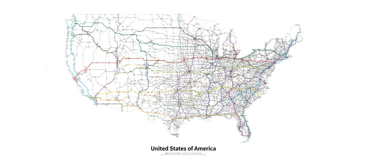
We all wish the United States had better trains. (If you don’t, you should.) That’s why this subway-style map of every U.S. Highway and Interstate in the country is so much fun. You can almost imagine heading down to your local stop for a quick jaunt up the East Coast. If only…
![]()
Where exactly am I? That’s the question Nokia is facing, not in its position following the Microsoft deal that will see it shed its phone business, but in how it’s … Continue reading

I’m proud to be an American where at least I know… we bone the most. At least according to this map which measures the frequency of sex and duration of sex by country. We don’t have the longest sex, though; that honor goes to Australia. Those down under have sessions that last for a "marathon" time of a little over 4 minutes.
![]()

As anyone who’s driven through Middle America knows, it feels like there’s very few places in the U.S. that don’t have at least a few inhabitants. But as a map by cartographer Nik Freeman proves, there are still some amber waves of grain and fruited plains that remain. Emphasis on some.
![]()
Self-driving cars may need to show some self-restraint when it comes to their “better than human” reflexes and abilities, the Nokia HERE team working on autonomous vehicle technologies suggests, if … Continue reading

If you Google Map Guéckédou, the Guinean city smack dab in the Ebola virus’s deadly domain right now, you’d see just an abstract blotch of beige and yellow. Zoom all the way in on satellite view, and you can barely make out the outlines of buildings. Don’t even think about trying Street View. Google Maps simply reflects the state of mapping in parts of Guinea. There are no good maps of Guéckédou—until the good folks of the internet help create one.
![]()
This is site is run by Sascha Endlicher, M.A., during ungodly late night hours. Wanna know more about him? Connect via Social Media by jumping to about.me/sascha.endlicher.